


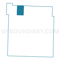
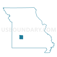
Flemington Voting District, Polk County, Missouri
About
Outline

Summary
| Unique Area Identifier | 609458 |
| Name | Flemington Voting District |
| County | Polk County |
| State | Missouri |
| Area (square miles) | 17.42 |
| Land Area (square miles) | 17.37 |
| Water Area (square miles) | 0.05 |
| % of Land Area | 99.72 |
| % of Water Area | 0.28 |
| Latitude of the Internal Point | 37.77436180 |
| Longtitude of the Internal Point | -93.48836300 |
Maps

Graphs
Select a template below for downloading or customizing gragh for Flemington Voting District, Polk County, Missouri


Neighbors
Neighoring Voting District (by Name) Neighboring Voting District on the Map
- Campbell Voting District, Polk County, MO
- Cliquot Voting District, Polk County, MO
- Elkton Voting District, Hickory County, MO
- Jefferson Voting District, Polk County, MO
- Johnson Voting District, Polk County, MO
- Weaubleau Voting District, Hickory County, MO
Top 10 Neighboring County Subdivision (by Population) Neighboring County Subdivision on the Map
- Johnson township, Polk County, MO (1,681)
- Tyler township, Hickory County, MO (1,257)
- Weaubleau township, Hickory County, MO (903)
- Cliquot township, Polk County, MO (572)
- Campbell township, Polk County, MO (536)
- Jefferson township, Polk County, MO (528)
- Flemington township, Polk County, MO (292)